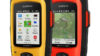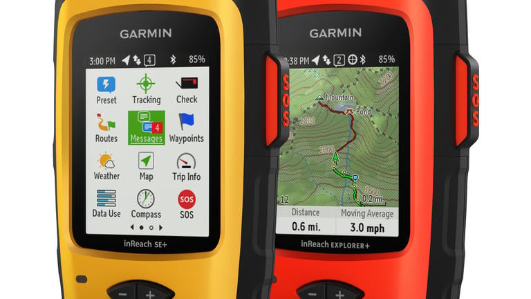
Garmin® announces first devices with Satellite Communication Technology: Introducing the inReach SE®+ and inReach Explorer®+
Garmin International Inc., a unit of Garmin Ltd. (NASDAQ: GRMN), today
announced the inReach SE+ and inReach Explorer+, the first Garmin
devices with inReach satellite communication technology, which was
acquired through the purchase of DeLorme in early 2016. The new inReach
SE+ and inReach Explorer+ have Pole to Pole global Iridium® satellite
coverage for two-way messaging and SOS alerting anywhere in the world.
Both models include a built-in GPS for location tracking and basic
navigation, and the inReach Explorer+ adds preloaded TOPO maps1,
compass, barometric altimeter and accelerometer.
From backcountry treks to international adventures, these new inReach
devices provide communication, location sharing, navigation and critical
SOS functions for anyone who loves getting away from it all, no matter
if it’s on land, water or in the sky, all while providing peace of mind
for friends and family back home. The inReach SE+ and inReach Explorer+
are being announced in conjunction with the Consumer Electronics Show in
Las Vegas, Nev., and will be showcased at the Garmin booth #35811.
“Satellite communication is something our customers have been asking
for, and we’re pleased to introduce the first Garmin inReach devices
following our acquisition of DeLorme last year,” said Dan Bartel, Garmin
vice president of worldwide sales. “Beneficial for both customers in the
field and family at home, the inReach SE+ and Explorer+ provide peace of
mind in addition to great functionality for people who want to explore
anywhere and communicate everywhere.”
Using the worldwide coverage of the Iridium satellite network, the
inReach SE+ and inReach Explorer+ can send and receive text messages
with any cell phone number, email address or another inReach device, so
users can be outside of cellular range without compromising their loved
ones’ peace of mind. Both devices have an interactive SOS, which
triggers an emergency response from GEOS®, the 24/7 search and rescue
monitoring center. After the SOS is received, inReach users are then
able to communicate back and forth with GEOS about the nature of the
emergency, and receive confirmation when help is on the way. Users can
also set up emergency contacts on their devices that will also be
notified in the event of an SOS.
Both the inReach SE+ and inReach Explorer+ have a built-in
high-sensitivity GPS that provides basic navigation, location and
tracking data, so users can follow routes, drop waypoints and find their
way back using an electronic bread crumb trail. The inReach Explorer+
adds more robust navigation options like preloaded DeLorme topographic
maps, built-in digital compass, barometric altimeter and accelerometer.
Similar to previous DeLorme devices, the inReach SE+ and inReach
Explorer+ are compatible with the web-based MapShare portal. With
MapShare, the inReach device sends the user’s trip data, such as tracks
and waypoint updates at preselected intervals, so friends and family can
follow user’s whereabouts, request a location update and exchange
messages.
With a compatible smartphone2, the inReach SE+ and Explorer+
can sync with the free Earthmate app for even more compatibility and
convenience. With the Earthmate® app, users can access unlimited maps,
aerial imagery, U.S. NOAA charts and USGS Quad Sheets. More data, like
game management units and parcel information for hunters, is available
for purchase. Users can also get optional weather updates and premium
weather packages directly to the handheld and the Earthmate app.
Additionally, every inReach device comes with free access to a
cloud-powered portal so users can plan trips and waypoints, sync and
manage their device, store all their tracking data and more.
On a single charge, the inReach SE+ and Explorer+ can get up to 100
hours of battery life in tracking mode and up to 30 days in power saving
mode. Rugged and designed to withstand the elements, these devices are
impact resistant and have an IPX7 water rating3.
To access the Iridium network and communicate with an inReach SE+ or
Explorer+, an active satellite subscription is required. Depending on
usage level, users can opt for an annual contract package or a flexible
month-to-month airtime plan, which allows them to pay for service only
when they need it. Annual plans range from $11.95 to $79.95 per month
(plus activation fee), and month-to-month plans range from $14.95 to
$99.95 per month.
The inReach SE+ and inReach Explorer+ will be available in the first
quarter of 2017. The inReach SE+ will have a suggested retail price of
$399.99, and the inReach Explorer+ will have a suggested retail price of
$449.99.
The inReach SE+ and inReach Explorer+ are the latest solutions from
Garmin’s expanding outdoor segment, which focuses on developing
technologies and innovations to enhance users’ outdoor experiences.
Whether hiking, hunting, geocaching, golfing, or using satellite
communication, Garmin outdoor devices are becoming essential tools for
outdoor enthusiasts of all levels. For more information about Garmin’s
other outdoor products and services, go to http://www.garmin.com/outdoors, www.garmin.blogs.com and http://twitter.com/garmin.
For decades, Garmin has pioneered new GPS navigation and wireless
devices and applications that are designed for people who live an active
lifestyle. Garmin serves five primary business units, including
automotive, aviation, fitness, marine, and outdoor recreation. For more
information, visit Garmin’s virtual pressroom at garmin.com/newsroom,
contact the Media Relations department at 913-397-8200, or follow us at facebook.com/garmin,
twitter.com/garmin,
or youtube.com/garmin.
| 1 |
Preloaded inReach TOPO maps are not compatible with other Garmin devices; other Garmin maps are not compatible with this device. |
|
| 2 |
Compatible smartphone required. Visit Garmin.com/BLE |
|
| 3 |
Visit Garmin.com/waterrating |
About Garmin
Garmin International Inc. is a subsidiary of Garmin Ltd. (Nasdaq: GRMN).
Garmin Ltd. is incorporated in Switzerland, and its principal
subsidiaries are located in the United States, Taiwan and the United
Kingdom. Garmin, DeLorme, inReach SE, inReach Explorer and Earthmate are
registered trademarks of Garmin Ltd. or its subsidiaries.
Notice on Forward-Looking Statements:
This release includes forward-looking statements regarding Garmin Ltd.
and its business. Such statements are based on management’s current
expectations. The forward-looking events and circumstances discussed in
this release may not occur and actual results could differ materially as
a result of known and unknown risk factors and uncertainties affecting
Garmin, including, but not limited to, the risk factors listed in the
Annual Report on Form 10-K for the year ended December 26, 2015, filed
by Garmin with the Securities and Exchange Commission (Commission file
number 0-31983). A copy of such Form 10-K is available at http://www.garmin.com/aboutGarmin/invRelations/finReports.html.
No forward-looking statement can be guaranteed. Forward-looking
statements speak only as of the date on which they are made and Garmin
undertakes no obligation to publicly update or revise any
forward-looking statement, whether as a result of new information,
future events, or otherwise.
FCC Notice:
The inReach SE+ and inReach Explorer+ have not been authorized as
required by the rules of the Federal Communications Commission. These
devices are not, and may not be, offered for sale or lease, or sold or
leased, until authorization is obtained.
Contacts
-
Images