Garmin Pilot adds Graphical Airspace and Obstacle NOTAMs for pre-flight planning and enhanced inflight awareness
Flight Profile View also updated to include quick access bar and Pinch-to-Zoom capability
OLATHE, Kan./November 17, 2020 – Garmin® International Inc., a unit of Garmin Ltd., is pleased to announce the addition of new features to the Garmin Pilot™ application for Apple mobile devices, offering the ability to reference graphical airspace and obstacle NOTAMs during pre-flight planning and for increased situational awareness inflight. Additional features include an enhanced user interface for Profile View, allowing pilots the ability to access important information such as weather, PIREPs, and more, faster than ever before.
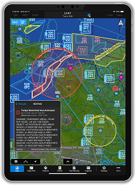
Graphical Airspace NOTAMS
Airspace NOTAMS are now available as a graphical overlay on the map and can be depicted as a circle or other shape with the type and associated altitude of the NOTAM labeled for even more clarity depending on the selected zoom level. NOTAMs that are scheduled to become active in the next 24 hours are displayed in yellow to help alert pilots in advance and aid with flight planning, with a brighter contrast for areas showing upcoming restricted airspace. Active airspace NOTAMs are color-coded depending on the following classifications:
• Red: Restricted and Danger NOTAMs, such as Prohibited Areas
• Orange: Alert and Warning NOTAMs, including Military Operation Areas (MOA)
• Gray: Flight Data Center (FDC) NOTAMS such as Instrument Approach Procedure changes
• Purple: Other NOTAMs such as Parachute Jumping areas
For convenience, airspace NOTAMs can be viewed from either the map or flight plan page by selecting the NOTAMs layer from the map overlays menu. Pilots can view NOTAMs in both decoded and raw text by selecting the NOTAM segment in the radial menu. Further, NOTAMs may also be viewed by selecting the NOTAMs widget in spilt-screen mode.
Graphical Obstacle NOTAMs
Obstacle NOTAMs use pink obstacle figures on the map in order to differentiate obstacle NOTAMs from permanent obstacles and are displayed anytime the NOTAM or obstacle layer is enabled. Those obstacles that have since been removed are displayed for reference as a pink “X.” Obstacle NOTAMs are available from the map or flight plan page by selecting overlays from the map layer icon with the ability to be viewed in both decoded and raw text by selecting the obstacle segment in the radial menu. Also, for convenience pilots have the ability to view an Obstacle NOTAM list from the airport page and by tapping the map icon for a selected NOTAM, jump to that NOTAM right on the map.
Enhancements to the Flight Profile View
The new quick access bar in the Flight Profile View allows pilots to display critical flight information such as weather, PIREPs, and traffic from compatible Garmin ADS-B traffic sources with just a single touch. Using the new and simple Pinch-to-Zoom capability, pilots now have the ability to more seamlessly review parts of the flight by focusing on a particular segment in the Profile View while still being able to reference the basic flight profile above.
The newest release of Garmin Pilot, version 10.3 for Apple mobile devices is available immediately. For new customers, Garmin Pilot is available in the Apple App Store as a free download for the first 30 days. After the 30-day trial period, customers may purchase an annual subscription of Garmin Pilot starting at $79.99. Garmin Pilot is supported by Garmin’s award-winning aviation support team, which provides 24/7 worldwide technical and warranty support. Please visit www.garmin.com/aviation for additional information.
Garmin’s aviation business segment is a leading provider of solutions to OEM, aftermarket, military and government customers. Garmin’s portfolio includes navigation, communication, flight control, hazard avoidance, an expansive suite of ADS-B solutions and other products and services that are known for innovation, reliability, and value. For more information, visit Garmin’s virtual pressroom at garmin.com/newsroom, contact the Media Relations department at 913-397-8200, or follow us at facebook.com/garmin, twitter.com/garminnews, instagram.com/garmin or youtube.com/garmin.
About Garmin International, Inc.
Garmin International Inc. is a subsidiary of Garmin Ltd. (Nasdaq: GRMN). Garmin Ltd. is incorporated in Switzerland, and its principal subsidiaries are located in the United States, Taiwan and the United Kingdom. Garmin is a registered trademark.
All other brands, product names, company names, trademarks and service marks are the properties of their respective owners. All rights reserved.
Notice on Forward-Looking Statements
This release includes forward-looking statements regarding Garmin Ltd. and its business. Such statements are based on management’s current expectations. The forward-looking events and circumstances discussed in this release may not occur and actual results could differ materially as a result of known and unknown risk factors and uncertainties affecting Garmin, including, but not limited to, the risk factors listed in the Annual Report on Form 10-K for the year ended December 28, 2019, filed by Garmin with the Securities and Exchange Commission (Commission file number 0-31983). A copy of such Form 10-K is available at http://www.garmin.com/aboutGarmin/invRelations/finReports.html. No forward-looking statement can be guaranteed. Forward-looking statements speak only as of the date on which they are made and Garmin undertakes no obligation to publicly update or revise any forward-looking statement, whether as a result of new information, future events, or otherwise.
Contact
Carly Hysell
Garmin International, Inc.
Phone | 913-397-8200
E-Mail | [email protected]
Public Company Information
NASDAQ:GRMN