Garmin Marine, Complete Electronics Solutions for Any Vessel
Bangkok/ March 27, 2012 – Garmin Corporation, a unit of Garmin Ltd., the global leader in satellite
navigation,
proudly unveil a brand new stand featuring the best selection of marine products. Check out
the touchscreen
chartplotters; the latest GHP™ 12 Autopilot for Sailboat, the integrated VHF communications;
or
the growing array of NMEA 2000 instruments; plus the best sell 7-inch touch screen standalone chartplotter,
the
new line of Garmin Asian dedicated fish finder as well as the rugged handhelds. They are easy to
use!
Look no further for all your marine electronics requirements than Garmin, the marine experts. This
new
line of marine product is being announced in conjunction with the Phuket International Boat Show,
29th
March to 1st April, RPM International Exhibition & Conference Center,
Thailand, and will
be showcased in the Garmin booth (#15) at this year’s show.
7-inch
standalone
chartplotter
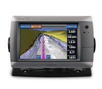 Garmin introduced the GPSMAP 720s – the first touchscreen controlled
stand-alone
marine chartplotters with radar capability and built-in sonar at an affordable price that’s
easy
to justify for any boat or budget. The GPSMAP 720s features a built-in 1kW capable sonar
transceiver
that can clearly define fish targets and terrain features as far down as 2,000 feet to keep
you apprised
of what’s happening under the surface.
Garmin’s chartplotter GPSMAP 720s
features
a standard radar port that lets you connect with any Garmin GMR™ series marine radar for
target
scanning on your chartplotter screen. Whether you’re adding radar now or in the future,
you’ll
enjoy the convenience of “plug-and-play” installation, as well as the power,
range and high-definition
targeting of Garmin’s proven radar offerings. These units are the
first non-network radar-capable
units offered in Garmin’s marine product line up, and offer the
perfect solution for the cost-conscious
mariner who wants to take advantage of radar capabilities without
the network price. In addition,
these new units offer full NMEA 2000 connectivity and make it easy
to monitor engine, fuel, autopilot,
weather and other onboard sensor data via the chartplotter.
Like
the other Garmin touchscreen
marine products, these units feature a sophisticated and elegant “flat-screen”
physical design
that complements today’s modern boats. Boasting a sleek 7-inch super-bright,
waterproof (IPX7
standards) touchscreen display, the GPSMAP 720s offers unprecedented extremes of brightness
for daytime
readability with super low-level dimming for optimum night vision. With a built-in high-sensitivity
GPS
receiver, these new chartplotters are the perfect navigation solution for a single station vessel,
and
with their small footprint, can fit onboard your vessel where other larger units cannot. The
built-in
GPS receiver provides installation location flexibility, and therefore can also effectively
serve as
the back-up navigation station on a larger yacht.
Asian dedicated
fish
finder
The premier high resolution Fishfinder 350C dedicated for Asian market features
an
ultra-sharp 272×480 pixel 5-inch WQVGA screen, a powerful 300-watt sonar transmitter, and offers excellent
fish
arch display and bottom tracking as deep as 1,500 feet. The Fishfinder 350C is dual beam (200/77
kHz)
capable and gives optimized performance for deep or shallow water, offering wide-angle (up to 120°)
coverage
to target fish beyond the sides of your boat and the ability to scan bottom profiles down to
1,500 feet.
Benefit
for the professional fishermen like you, Fishfinder 350C features with dedicated
button on its right
side for you to quickly adjust the setting you need for “Gain”, “Range”,
and
“Zoom” function.
|
|
 |
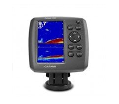
Don’t
you worry your fish finder being stolen!
You can easily remove Fishfinder 350C from mount and take the
device with you off boat by its brilliant
mounting design. Installation takes only a few minutes with
using the tilt/ swivel mount and versatile
transom/ trolling motor-mount transducer included in the box.
An optional flush-mount kit is also available.
Marine
GPS handhelds
GPSMAP
78s, the newest of Garmin’s next generation marine-friendly
GPS handheld feature a new contemporary
industrial design with rubber side grips that’s ideal for
navigating the great outdoors. Furthermore,
it supports Thai and Bahasa Indonesia, which makes it much
more user-friendly in Asia.
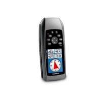 Thanks to the bright, highly transflective 65K color LCD display with
backlight, GPSMAP
78s is easier than ever to read and use in all conditions. Like earlier GPSMAP generations,
these new
handhelds will keep the same soft-key user interface and overall sleek, easy-to-use design
– including
in a rugged and waterproof housing that floats. Other key upgrades to the GPSMAP 78s
includes user-defined
profiles and a 3-axis tilt-compensated electronic compass, which shows your heading
even when you’re
standing still. The new GPSMAP 78s also support wireless exchange of tracks, waypoints,
routes and geocaches
with compatible Oregon®, Dakota®, Colorado® and Foretrex® devices.
Weighing
7.7
ounces, the new GPSMAP 78s lasts up to 20 hours on two AA batteries. Each device has a high-sensitivity
GPS
receiver with HotFixTM, which automatically calculates and stores critical satellite information
and
can use that information to quickly calculate a position. The new GPSMAP 78s has 1.7 GB of internal
memory
and a microSDTM card slot for optional map data, so users have the ability to add additional BlueChart®
g2
marine charts, topographic maps or CityNavigator® data for turn-by-turn routing on roads. With
these
units, you can store up to 2,000 waypoints, 200 routes and a tracklog of up to 10,000 points and
200
saved tracks.
For more information, including availability, visit www.garmin.com.sg/products/onthewater/
About
Garmin
Corporation
Garmin Corporation, is a unit of Garmin Ltd. (Nasdaq: GRMN), the global
leader
in satellite navigation. Since 1989, this group of companies has designed, manufactured, marketed
and
sold navigation, communication and information devices and applications – most of which are
enabled
by GPS technology. Garmin’s products serve automotive, mobile, wireless, outdoor recreation,
marine,
aviation, and OEM applications. Garmin Ltd. is incorporated in Switzerland, and its principal
subsidiaries
are located in the United States, Taiwan and the United Kingdom. Garmin, Bluechart,
City Navigator,
Colorado, Foretrex and Oregon are registered trademarks and Dakota, is a trademark of
Garmin Ltd. or
its subsidiaries.
Notice on forward-looking statements:
This
release includes forward-looking statements regarding Garmin Ltd. and its business. All statements
regarding
the company’s future product introductions are forward-looking statements. Such statements
are
based on management’s current expectations. The forward-looking events and circumstances discussed
in
this release may not occur and actual results could differ materially as a result of known and unknown
risk
factors and uncertainties affecting Garmin, including, but not limited to, the risk factors listed
in
the Annual Report on Form 10-K for the year ended December 27, 2008, filed by Garmin with the Securities
and
Exchange Commission (Commission file number 0-31983). A copy of Garmin’s Form 10-K can be downloaded
at
www.garmin.com/aboutGarmin/invRelations/finReports.html. No forward-looking statement can be guaranteed.
Forward-looking
statements speak only as of the date on which they are made and Garmin undertakes no
obligation to publicly
update or revise any forward-looking statement, whether as a result of new information,
future events, or otherwise