Take it to the extreme with the GPSMAP 62 Handheld
Garmin, the global leader in satellite navigation, is pleased to announce the GPSMAP® 62 series of rugged handheld GPS devices. These tough, robust navigators introduce a sleek updated look, enhanced mapping options and many technical innovations to the GPSMAP 60 range admired and trusted by adventurers, hikers and geocachers of all ages.
“The GPSMAP® 60 series has been one of our most popular product lines, and the new GPSMAP® 62 series improves the form and functionality to make a best-in-class device even better,” said Andrew Silver, Garmin’s Outdoor Product Manager. “Whether you’ve been using Garmin for years or are buying your first handheld, GPSMAP® 62 is ideal as it combines our new innovation in GPS handheld technology with the popular and reliable features of a proven performer.”
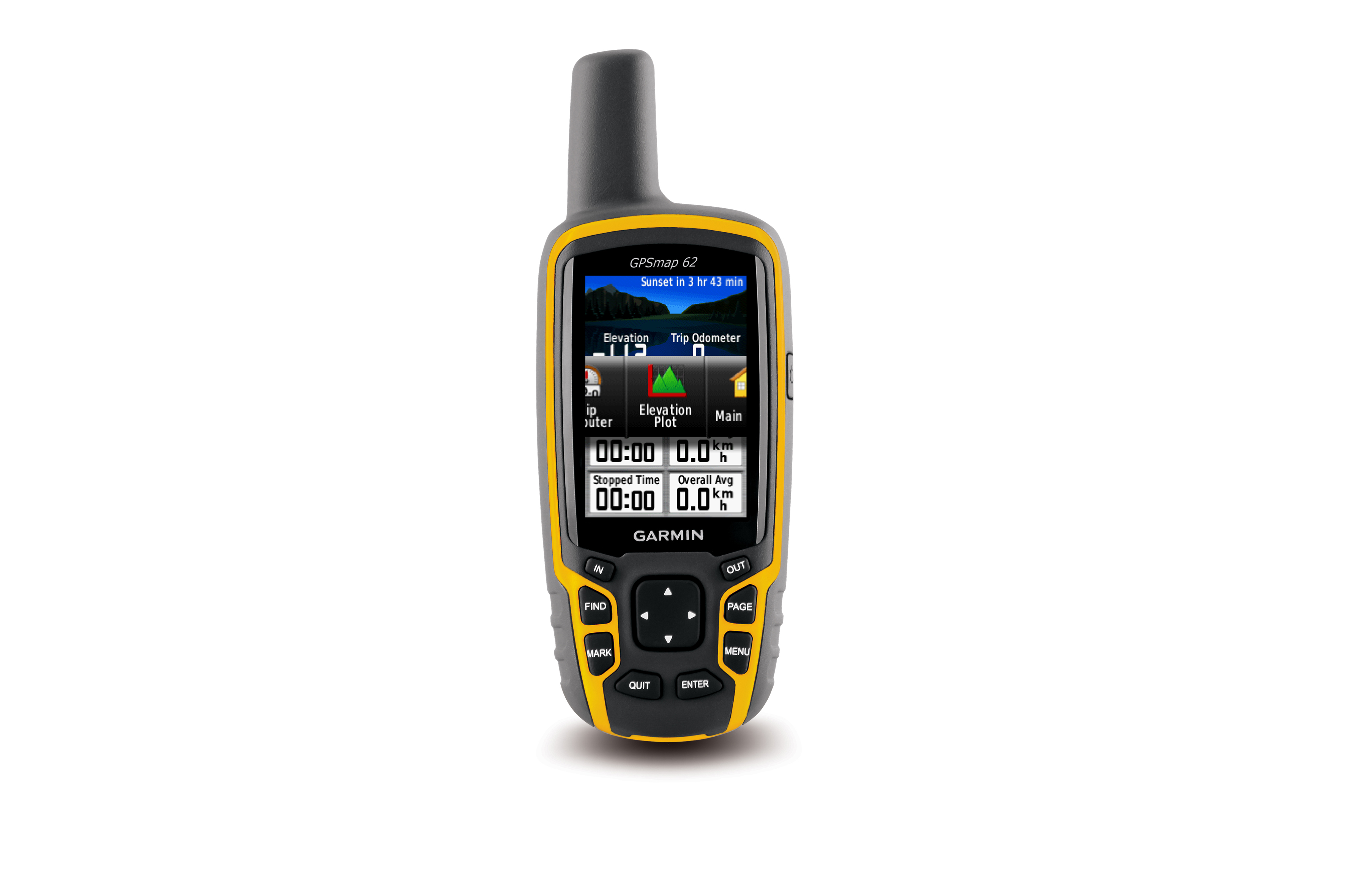
Boasting a 2.6-inch sunlight-readable colour display, up to 20 hours of battery life and a high-sensitivity GPS receiver plus quad helix antenna for unparalleled reception, the GPSMAP 62 series includes three distinct waterproof models to suit various activities and interests. The basic GPSMAP® 62 includes a built-in worldwide basemap with shaded relief.
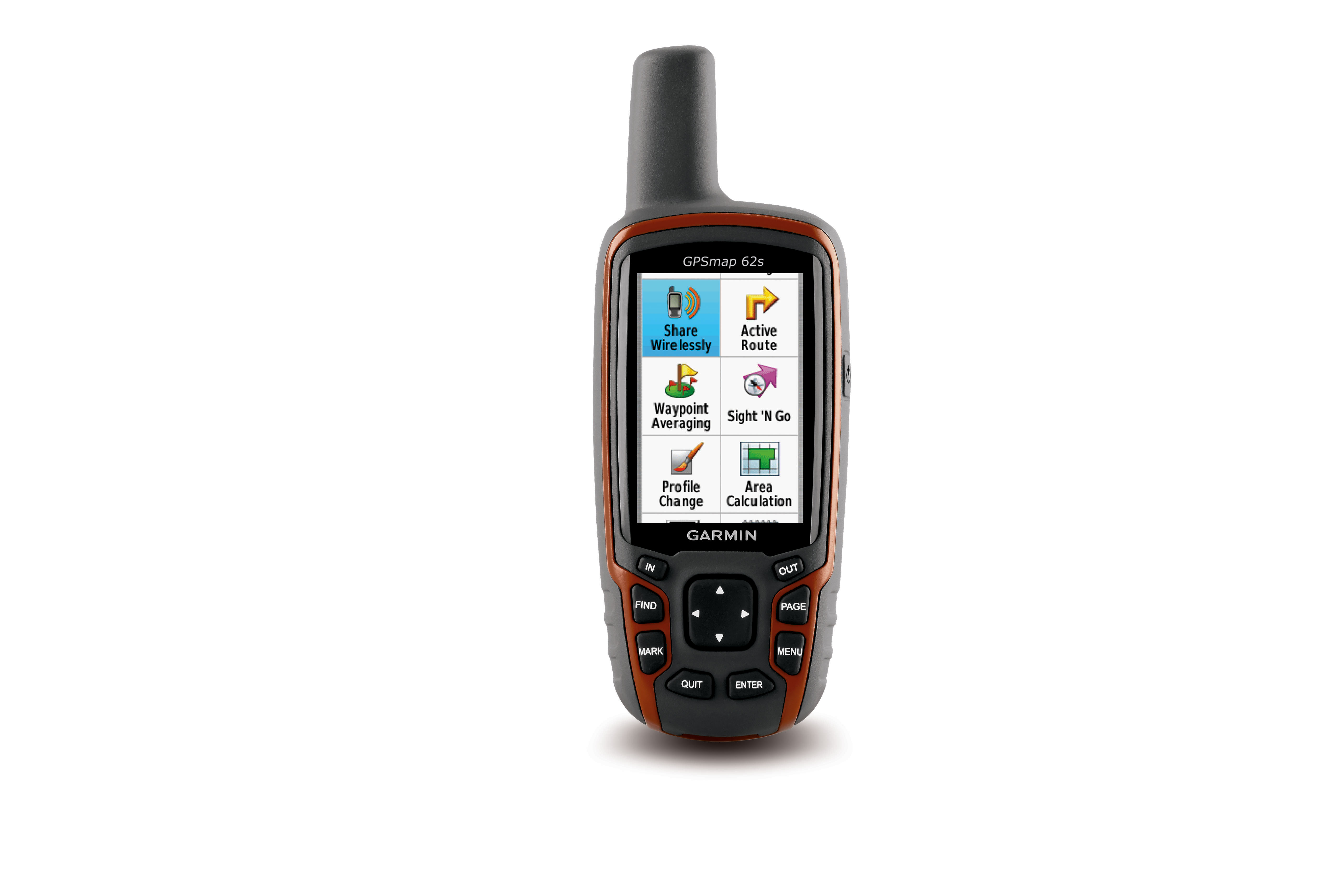
The GPSMAP® 62s adds a 3-axis tilt-compensated electronic compass and wireless connectivity for sharing routes, tracks, waypoints and geocaches between other compatible Garmin handhelds. GPSMAP 62s also features a barometric altimeter that tracks changes in pressure to pinpoint your precise altitude. Users can also plot barometric pressure over time, to keep an eye on changing weather conditions.

GPSMAP® 62st includes preloaded 1:100,000 scale recreational mapping with street-level detail, elevation contours, points of interest and land use descriptions for more than 33 countries across Europe. In addition, you can search for points of interest by name or proximity to your location and view descriptive details for terrain contours, topo elevations, summits and geographical points.
For more detailed mapping on your handheld, Garmin GB Discoverer™ is available to buy on a microSD card. It is available in 1:50k (the same scale as Ordnance Survey Landranger maps) for the whole of Great Britain and 1:25k (the same scale as Ordnance Survey Explorer maps) for national parks and trails. When used on your Garmin Handheld it offers all the benefits of traditional paper maps including contours, boundary identification and public rights of way, with the added bonus of turn-by-turn navigation as you drive including directions to thousands of points of interest. Garmin EIRE Discoverer™ is also available for the Republic of Ireland. To find out more about Garmin GB Discoverer and the many TOPO map titles covering popular destinations throughout Europe visit http://www.garmin.com//garmin/cms/site/uk/mappingsolutions.
The GPSMAP® 62 series is also compatible with a host of other useful applications. Garmin’s subscription-based BirdsEye™ Satellite Imagery, can transfer high-resolution satellite images to their handheld and seamlessly integrate those images into the built-in mapping for a true representation of their surroundings. More details can be found at www.garmin.com/birdseyesatimagery.
Garmin’s free Custom Maps can be used to transfer paper or digital maps onto the GPSMAP® 62. Details, labels and landmarks of existing maps, such as ski piste routes or mountain bike trails are just two examples that can be put onto your handheld so you can navigate with them. More details can be found at www.garmin.com/CustomMaps
When you’ve finished your adventure, the free online community at Garmin Connect™ (http://garminconnect.com) enables you to store, analyse, and share where you’ve been. Outdoor and fitness enthusiasts alike can share activities on Facebook and Twitter, export to Google™ Earth or relive the activity in table view, calendar view or on a variety of maps including our new embedded Google™ Earth view.
The GPSMAP® 62 series even offers paperless geocaching enabling you to quickly download cache information directly to the device. See www.garmin.com/geocaching.
Each device in the GPSMAP® 62 series has a high-sensitivity GPS receiver with HotFix™, which automatically calculates and stores critical satellite information to quickly calculate a position. The GPSMAP 62 series is made even more versatile through its universal mounting system, compatible with the same accessories as Garmin’s Oregon, Dakota and Colorado products. Other key upgrades include photo navigation and onboard memory for downloading maps.
About Garmin
The global leader in satellite navigation, Garmin Ltd. and its subsidiaries have designed, manufactured, marketed and sold navigation, communication and information devices and applications since 1989 – most of which are enabled by GPS technology. Garmin’s products serve automotive, mobile, wireless, outdoor recreation, marine, aviation, and OEM applications. Garmin Ltd. is incorporated in the Cayman Islands, and its principal subsidiaries are located in the United States, Taiwan and the United Kingdom. For more information visit Garmin's media centre at www.garmin.co.uk/mediacentre. Garmin is a registered trademark of Garmin Ltd. or its subsidiaries. All other brands, product names, company names, trademarks and service marks are the properties of their respective owners. All rights reserved.
Notice on forward-looking statements:
This release includes forward-looking statements regarding Garmin Ltd. and its business. All statements regarding the company’s future product introductions are forward-looking statements. Such statements are based on management's current expectations. The forward-looking events and circumstances discussed in this release may not occur and actual results could differ materially as a result of known and unknown risk factors and uncertainties affecting Garmin, including, but not limited to, the risk factors listed in the Annual Report on Form 10-K for the year ended December 29, 2007 filed by Garmin with the Securities and Exchange Commission (Commission file number 000-31983). A copy of Garmin’s Form 10-K can be downloaded at www.garmin.com/aboutGarmin/invRelations/finReports.html. No forward-looking statement can be guaranteed. Forward-looking statements speak only as of the date on which they are made and Garmin undertakes no obligation to publicly update or revise any forward-looking statement, whether as a result of new information, future events, or otherwise.