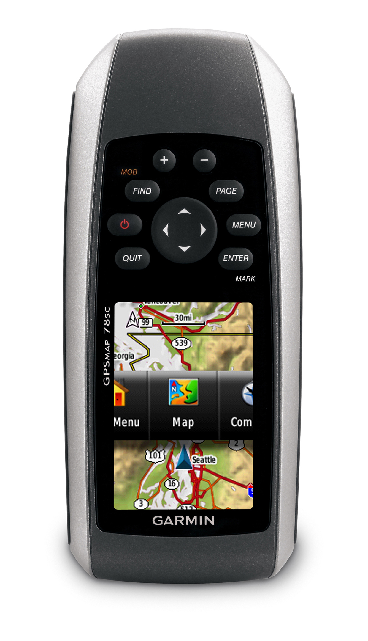
Garmin® Rolls Out New High-Performance Marine Handhelds
Garmin, the global leader in satellite navigation, is pleased to announce the GPSMAP 78s and the GPSMAP 78 – the latest in the range of next generation marine-friendly GPS handhelds.
The GPSMAP 78 series feature a new contemporary industrial design with rubber side grips that are ideal for navigating the great outdoors. Garmin’s flagship model, the 78s, also adds new high-end features including a 3-axis tilt-compensated electronic compass and wireless data transfer between compatible units.
Nigel Craine, Marine and OEM Product Manager for Garmin said: “The GPSMAP 78 series demonstrates modern design and high-tech features, whilst retaining the ruggedness and durability that mariners have come to know and appreciate from the GPSMAP series.
“The GPSMAP 78 series is the perfect companion for any grab bag, Kayaker or RIB Owner, giving instant access to important information when you need it most. It’s simple to use and if you do happen to drop it over the side, it floats!”
Thanks to the bright, highly transflective 65K colour LCD display with backlight, each unit in the GPSMAP 78 series is easier than ever to read and use in all conditions.
Like earlier GPSMAP generations, these new handhelds will keep the same soft-key user interface and overall sleek, easy-to-use design – including a rugged and waterproof housing that floats. Other key upgrades to the GPSMAP 78s include user-defined profiles and a 3-axis tilt-compensated electronic compass, which shows your heading even when you’re standing still. The new GPSMAP 78s also supports wireless exchange of tracks, waypoints, routes and geocaches with compatible Oregon®, DakotaTM, Colorado® and Foretrex® devices.
Weighing just 219g, the new GPSMAP 78 models last up to 20 hours on two AA batteries. Each device has a high-sensitivity GPS receiver with HotFixTM, which automatically calculates and stores critical satellite information and can use that information to quickly calculate a position.
The new GPSMAP 78 models have 1.7 GB of internal memory and a microSDTM card slot for optional map data, so users have the ability to add additional BlueChart® g2 marine charts, topographic maps or CityNavigator® data for turn-by-turn routing on roads. With these units, you can store up to 2,000 waypoints, 200 routes and a tracklog of up to 10,000 points and 200 saved tracks.
A built-in worldwide shaded relief basemap comes preloaded on each new 78 series handheld. The GPSMAP 78 series also supports Garmin Custom Maps – a free utility that transforms paper and electronic maps into downloadable maps for your compatible Garmin handheld device, bringing details, labels and landmarks for your existing paper or electronic map to your device. For more information, visit www.garmin.com/CustomMaps.
Manufacturer’s suggested retail prices are as follows: £349.99 for GPSMAP 78s and £299.99 for GPSMAP 78. The 78 series is expected to be available in May, 2010. For more information, visit www.garmin.co.uk/onthewater