Garmin® builds camera into GPSMAP® 62 handhelds
Garmin, the global leader in satellite navigation, today announced exciting additions to its flagship GPSMAP 62 series range of outdoor handheld devices. GPSMAP 62stc and GPSMAP 62sc now have built-in 5 megapixel cameras with automatic geotagging to capture the highlights of any adventure and enable you to share locations visited or navigate back to them.
Breakdown:
- 5 megapixel auto-focus camera with geotaging
- Waterproof to IPX7 standards, ample built-in memory (3.5 GB for both models)
- 2.6” sunlight-readable colour display, 16 hours battery life
- Compatible with Garmin’s raster map download service BirdsEye™ Select
- Garmin GB Discoverer™ is available to buy on a microSD card, in 1:50 and 1:25K
- ANT+ for wireless sharing between compatible devices and interacting with chirp geocaching beacons (www.garmin.com/chirp). They can also monitor heart rate and cadence using related optional accessories.
- Available at the end of July 2011. The GPSMAP 62sc and GPSMAP 62stc have a RRP of £439.99 and £489.99 respectively.
“Having spent time in the outdoors talking to enthusiasts, we know climbers, walkers, mountain bikers and other outdoors enthusiasts often don’t have the time or energy to dig through their rucksacks every time they see something memorable or worth sharing later,” said Martin Resch, Garmin’s Outdoor Product Manager, EMEA. “The built-in camera seamlessly integrates photography into your basic navigation, ensuring with every adventure you’ll have a story to tell with pictures as well as words.”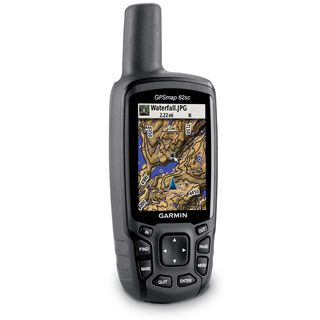
Picture perfect: Whenever a picture is taken in stunning clarity with the 5 megapixel auto-focus camera on GPSMAP 62stc or GPSMAP 62sc, the photograph is geotagged – meaning the location is saved and encoded into the file – so that the geographical coordinates can be used later as a point of reference or as a destination that can be reached through GPS guidance and directions. And because the GPSMAP range is waterproof to IPX7 standards, the built-in camera will still be snapping photos even in the worst conditions. Ample built-in memory (3.5 GB for both models) allows you to take plenty of pictures on the trail and save the downloading and editing for later. Once your GPSMAP 62stc or GPSMAP 62sc is connected via USB, you can use my.Garmin.com to review the photos, make your selection, upload and store those images online for friends and family around the world to enjoy.
Options abound: Boasting a 2.6” sunlight-readable colour display, an intuitive push-button interface, up to 16 hours battery life in addition to its high-sensitivity GPS receiver and quad helix antenna for unparalleled reception, the GPSMAP 62 series features various models and custom dashboards to suit myriad activities and interests. And thanks to enhanced navigation and the digital elevation model (DEM) data, users navigating to a destination on an active track will see changes in elevation ahead as well as where they’ve been. Also, waypoints and other key locations along the active track – such as start, end and high and low elevation points – appear on the map and active route pages.
What’s inside: GPSMAP 62 ‘s’ models include a 3-axis tilt-compensated electronic compass and wireless connectivity for sharing routes, tracks, waypoints and geocaches between other compatible Garmin handhelds. These models feature a barometric altimeter that tracks changes in pressure to pinpoint your precise altitude. Users can also plot barometric pressure over time, enabling you to keep an eye on changing weather conditions. These devices use ANT+ for wireless sharing between compatible devices and interacting with chirp geocaching beacons (www.garmin.com/chirp). They can also monitor heart rate and cadence using related optional accessories.
Taming the terrain: GPSMAP 62 ‘t’ models come with built-in European 1:100K recreational maps with street-level detail and a worldwide basemap with shaded relief. Detailed coverage includes major trails, urban and rural roads, coastlines, rivers and lakes as well as national and local parks, forests and wilderness areas. In addition, you can search for points of interest by name or proximity to your location and view descriptive details for terrain contours, topo elevations, summits and geographical points of interest.
Myriad mapping options: Each model in the GPSMAP 62 series is compatible with Garmin’s raster map download service BirdsEye™ Select (www.garmin.com/birdseye) as well as Garmin’s free Custom Maps utility for transferring paper or digital maps onto a handheld. Garmin GB Discoverer™ is available to buy on a microSD card. It is available in 1:50k (the same scale as Ordnance Survey Landranger maps) for the whole of Great Britain and 1:25k (the same scale as Ordnance Survey Explorer maps) for national parks and trails. You can also join a worldwide community and share your adventures at Garmin Connect™ (www.garminconnect.com). Compatible with both PC and Mac, these options complement the products already offered for Garmin devices, including City Navigator® NT for turn-by-turn directions on city streets, BlueChart® g2 for marine charting, and Garmin TOPO maps for incredible terrain detail (each sold separately).
Hunting for treasure: Geocachers have much more fun by going paperless with the GPSMAP 62 series, quickly downloading cache information directly to the device. Each model stores and displays key information such as location, terrain, difficulty, hints and description, so that you don’t have to carry printouts with you. Learn more about geocaching, how to get started and going paperless at www.garmin.com/geocaching and www.OpenCaching.com.
Since its inception in 1989, Garmin has delivered 85 million GPS enabled devices – far more than any other navigation provider. Garmin’s market breadth in the GPS industry is second to none, having developed innovative products and established a leadership position in each of the markets it serves: automotive, aviation, marine, fitness, outdoor recreation, tracking, and wireless applications.
The new GPSMAP 62 devices are expected to be available at the end of July 2011. The GPSMAP 62sc and GPSMAP 62 stc have a suggested retail price of £439.99 and £489.99 respectively. For more information about features, pricing and availability for all of Garmin’s new outdoor handhelds, visit garmin.co.uk/explore. For information about Garmin’s other products and services, go to www.garmin.co.uk, facebook.com/garminuk and twitter.com/garminuk
About Garmin
The global leader in satellite navigation, Garmin Ltd. and its subsidiaries have designed, manufactured, marketed and sold navigation, communication and information devices and applications since 1989 – most of which are enabled by GPS technology. Garmin’s products serve automotive, mobile, wireless, outdoor recreation, marine, aviation, and OEM applications. Garmin Ltd. is incorporated in Switzerland, and its principal subsidiaries are located in the United States, Taiwan and the United Kingdom. For more information visit Garmin's media centre at http://garmin.blogs.com/ukpr. Garmin is a registered trademark and GHP, GHC and GWS are trademarks of Garmin Ltd. or its subsidiaries. All other brands, product names, company names, trademarks and service marks are the properties of their respective owners. All rights reserved.
Notice on forward-looking statements
This release includes forward-looking statements regarding Garmin Ltd. and its business. All statements regarding the company’s future product introductions are forward-looking statements. Such statements are based on management's current expectations. The forward-looking events and circumstances discussed in this release may not occur and actual results could differ materially as a result of known and unknown risk factors and uncertainties affecting Garmin, including, but not limited to, the risk factors listed in the Quarterly Report on Form 10-Q for the quarter ended June 26, 2009 filed by Garmin with the Securities and Exchange Commission (Commission file number 0-31983). A copy of such Form 10-Q can be downloaded at www.garmin.com/aboutGarmin/invRelations/finReports.html. No forward-looking statement can be guaranteed. Forward-looking statements speak only as of the date on which they are made and Garmin undertakes no obligation to publicly update or revise any forward-looking statement, whether as a result of new information, future events, or otherwise.
xxxx

