Garmin Introduces the aera 660 – A Next Generation Aviation Portable
We are excited to announce the aera 660, a new cost-effective, purpose-built aviation portable designed with more capabilities and features than ever before. This affordable, feature-rich navigation device includes a stunning display, expanded Connext wireless capabilities, streamlined database updating and much more!
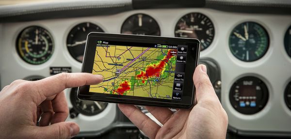
The aera 660 features a compact 5-inch touchscreen that boasts a bright, sunlight readable display that can be viewed in portrait or landscape modes. It also includes many of the renowned features of the aera and GPSMAP aviation portable series including our signature direct-to feature, while adding new Connext wireless capabilities, WireAware wire-strike avoidance technology, additional database options and more. Built-in Wi-Fi allows customers to more easily access the most up-to-date data, including U.S fuel prices, while added Bluetooth supports the display of ADS-B In traffic and weather from a variety of sources such as the GDL 39/GDL 39 3D, Flight Stream and the GTX 345 ADS-B transponder.
It is designed with an intuitive user interface that resembles our popular GTN 650/750 touchscreen series, G3X Touch and aera 795/796 portable series, so pilots can easily transition between the aera 660 and other Garmin products in the cockpit. Additionally, it features a mini-USB connector, micro SD card slot and removable battery accompanying a dedicated power button along the bezel. Depending on settings and external connections, pilots will receive up to four hours of battery life on a single charge.
When paired with the GTX 345, Flight Stream or the GDL 39/GDL 39 3D, ADS-B traffic and weather is wirelessly transferred and displayed on the aera. ADS-B traffic information may be viewed on the moving map page, chart page and dedicated traffic page, which also leverages patented features such as TargetTrend and TerminalTraffic. Weather-related decision-making is also easier, which helps pilots interpret datalink radar imagery more easily by animating NEXRAD radar imagery and multiple weather products can be overlaid on a single weather page for better analysis.
Comprehensive chart options provide pilots with an easy path to a paperless cockpit in a compact device, which may be qualified for use as either a Class I or Class II Electronic Flight Bag (EFB). Geo-referenced IFR enroute, VFR sectional charts and Garmin FliteCharts terminal procedures are also available as part of the database offerings. Using FliteCharts, pilots can easily view departure procedures (DPs), standard terminal arrival routes (STARs) and geo-referenced approach charts, all within the aera 660. Additionally, Garmin ChartView allows the display of Jeppesen charts with an optional subscription from Jeppesen. SafeTaxi geo-referenced airport diagrams also aid in situational awareness by identifying runways, taxiways, FBO’s, hangars and more relative to the aircraft’s position on the airport surface. A Smart Airspace feature conveniently highlights the airspace nearest the aircraft’s current altitude and de-emphasizes non-pertinent airspace so pilots can quickly identify their location relative to the airspace around them.

Availability of the aera 660 is expected later this month. For more information visit our website or contact us at [email protected].